
La Zenia Map
Handy La Zenia street map showing the resort on the Costa Blanca, Spain.
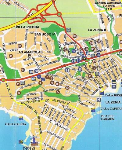 |
Map of Zenia - Costa Blanca - Spain
La Zenia Map: Above you will see a street map for the ever popular coastal resort of La Zenia situated on the southern Costa Blanca, Spain.
Situated in a region known as the Orihuela Costa, La Zenia has a popular beach and a fine 4 Star Hotel which is located beside the beach at the end of the Avenida de la Playa.
On the map you will see the main beach (Cala Bosque), and also the two beaches of La Zenia's neighbouring resort of Cabo Roig, these are Cala Capitan and Cala Caleta.
The road in yellow at the top of the map is the AP-7 motorway (junction 763) which is the main access point for La Zenia, the Orihuela Costa and for the golf urbanization of Villamartin which is nearby.
The renowned La Zenia Hotel is clearly marked ('H') beside Cala Bosque beach.
The road marked in red which runs horizontally is the main N-332 coast road, going left here takes you to Cabo Roig and onwards towards the Mar Menor and Cartagena, going right takes you to Playa Flamenca, Torrevieja and onwards to Alicante.
More La Zenia Info: HOME - HOTEL - PROPERTY - PAGES
More Costa Blanca Places: Playa Flamenca - Punta Prima - Campoamor - Cabo Roig
Costa Blanca Resort Guides: Cabo Roig (View Website)
HOME